GEO Heritage

Safety
Tips
GEO
Sites

Trails & More

Local
Food

Member-ship

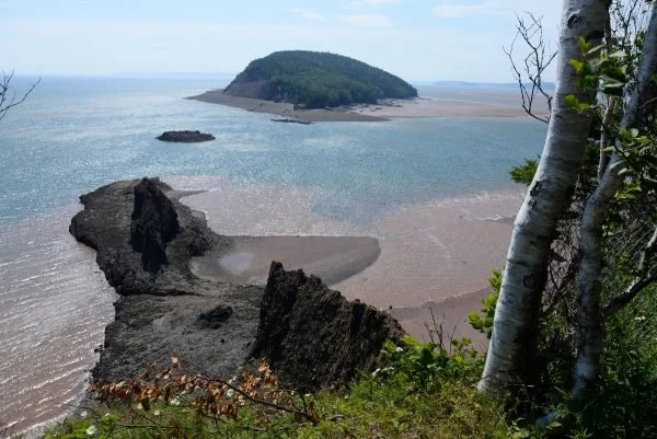
Anderson Cove & Squally Point
The wild coastline of the Cliffs of Fundy is nowhere more breath-taking than here. In Anderson Cove, a dizzying array of 355-million-year-old volcanic rocks and lake sediments record the squeezing and stretching that took place during the assembly of Pangea. A flat cliff top marks an ancient beach now perched high above the Bay of Fundy. This raised beach was created as the melting ice sheet retreated 16,000 years ago. As the great weight of glacial ice disappeared, the land rebounded, raising the beach to 37 metres (40 yd) above present sea level.
Geological Formation: Fountain Lake Group (cliffs)
Age: Carboniferous (circa 300 million years) and Quaternary (circa 10,000 years ago)
Directions: From Spicer Cove, continue past the bridge turning right towards Eatonville day use park of Cape Chignecto Provincial Park. From the parking area, hike the trail, bearing left at the trail junction. A well maintained loop takes you to interpreted lookoffs.
GPS Coordinates: 45.423464, -64.915193 – Anderson Cove
GPS Coordinates: 45.430155, -64.914953 – Squally Point
Tide Times: http://www.tides.gc.ca/eng/station?sid=235
Squally Point
Anderson Cove

Other Popular GeoSites
-
![]()
Ward Falls
-
![]()
Five Islands
-
![]()
Three Sisters
-
![]()
Cape D'Or